“Hope never abandons you; you abandon it. ” ~George Weinberg

Copyright © 2010 Deborah M. Zajac. All Rights Reserved.
“Hope never abandons you; you abandon it. ” ~George WeinbergJulia Pfeiffer Burns State Park

Big Sur
McWay Falls
Sunset
Pacific Ocean

McWay Fall
Julia Pfeiffer Burns State Park
Big Sur
California
Pacific Ocean
Lagoon

For the history buffs:
After passing through the specially constructed pedestrian underpass, the overlook trail comes out onto the face of a steep bluff about 100 feet above the ocean. The view includes a large sweep of ocean, miles of the Big Sur coastline, and looks directly down into McWay Cove, where a delightful little water-fall drops 80 feet from the granite cliffs. Prior to 1983, it fell directly into the sea, but a major landslide a half-mile north of the cove deposited so much sediment in McWay Cove the the waterfall now lands on a sandy beach. The “new” beach is not open to the public because the surrounding cliffs are extremely unstable.

Nikon D300s| AF-S Nikkor 17-35mm| Tripod

“One crowded hour of glorious life is worth an age without a name.” Thomas Osbert Mordaunt

Copyright © 2010 Deborah M. Zajac. All Rights Reserved.

McWay Fall
Julia Pfeiffer Burns State Park
Big Sur
California
Pacific Ocean
Lagoon

The sun was setting just behind me but before I moved to get that in a frame I just had to shoot this during the Golden hour.

For the history buffs:
After passing through the specially constructed pedestrian underpass, the overlook trail comes out onto the face of a steep bluff about 100 feet above the ocean. The view includes a large sweep of ocean, miles of the Big Sur coastline, and looks directly down into McWay Cove, where a delightful little water-fall drops 80 feet from the granite cliffs. Prior to 1983, it fell directly into the sea, but a major landslide a half-mile north of the cove deposited so much sediment in McWay Cove the the waterfall now lands on a sandy beach. The “new” beach is not open to the public because the surrounding cliffs are extremely unstable.

P.P. Added a little vibrance, and clarity, and wee bit recovery. Slight crop off the right side, and resized.

Nikon D300s
Nikkor 17-35mm f/2.8 AF-S

Baby Blue Eyes


Baby Blue Eyes, originally uploaded by dmzajac2004.

Filoli Gardens
Woodside,CA
Estate
Garden
Historical Site
Meet-Up

I met some of my Night Photography Meet-up group before heading up to the city (San Francisco) we toured the house and garden. It’s a beautiful estate. On Sat. it was horribly crowded so getting good shots was difficult. I must go back during the week when less people are about the place.

History for those who like it:
After the 1906 earthquake, many wealthy San Francisco families relocated to the Peninsula and built large estates. A
number of these families made their fotunes in the railroad, mining, banking, and mercantile boom of America’s Gilded Age. Filoli is the last of these estates remaining on all of its original 654 acres. Built by Mr. and Mrs. William Bowers Bourn II, who lived here between 1919 and 1936, the estate was sold to Mr. and Mrs. William P. Roth in 1937. In 1975, Mrs. Roth donated the estate to the National Trust for Historic Preservation. Today the property is open to the public from February through October with the help of more than 1,000 volunteers.

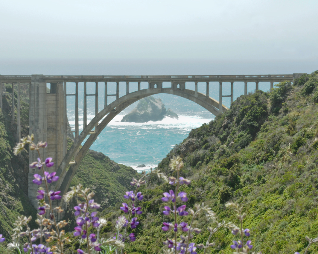
Bixby Bridge

Copyright © 2010 Deborah M. Zajac. ALL RIGHTS RESERVED

Bixby Bridge, originally uploaded by dmzajac2004.

Copyright © 2010 Deborah M. Zajac. All Rights Reserved.

Big Sur
Bixby Bridge
Old Coast Hwy
Hwy 1
Scenic California
Pacific Ocean
Earth Day

There were a lot of power wires in front and above this bridge I cloned out. How do you think it looks? Bad job?

The view is lovely from here. The Old Coast Hwy is a dirt road giving one an idea of what life was life was like before Hwy 1.

History
Bixby Creek Bridge is a reinforced concrete open-spandrels arch bridge in Big Sur, California. It is located 120 miles (190 km) south of San Francisco and 13 miles (21 km) south of Carmel in Monterey County along California Highway One.

Bixby Creek Bridge is important historically because it introduced automobile travel to Big Sur, connecting the remote coastal towns to each other.
It is 714 feet (218 m) long, 24 feet (7.3 m) wide, over 280 feet (85 m) high and has a main span of 320 feet (98 m). Its two heavy buttresses are unnecessary to support the structure, and later arch bridges such as the Frederick W. Panhorst Bridge omitted them from the design. It is “one of the most photographed features on the West Coast” because of its location along the scenic Central Coast of California, and has frequently been used in automobile commercials. The construction of the bridge began on August 24, 1931 and was completed on October 15, 1932. Local legend has it that during construction, a Chinese laborer was killed in a construction accident. Rather than delay construction with a police investigation, the body was thrown into the fresh concrete of the north pillar. This story is frequently told, but has not been corroborated. Before the bridge was opened on November 27, 1932, coastal travelers endured rough wagon roads over precipitous ridges and valleys. The 30-mile (48 km) journey from Monterey to the Big Sur River valley could take three days round trip. It has since become a regional landmark, and was used in the opening sequences of the television series Then Came Bronson and the film Play Misty for Me. The bridge figures prominently in posters and other publicity material of the Big Sur International Marathon.
~Wikipedia

Parade Ground View


Parade Ground View, originally uploaded by dmzajac2004.

Copyright © 2010 Deborah M. Zajac. All Rights Reserved.
Fort Baker
Parade Ground
US Coast Guard HQ
Horseshoe Cove
San Francisco Bay
San Francisco Skyline
California
Early Evening

Fort Baker is one of the most famous components of California’s Golden Gate National Recreation Area.
The Fort, which borders the City of Sausalito in Marin County and is connected to San Francisco by the Golden Gate Bridge,
served as an Army post until the mid-1990s, when the headquarters of the 91st Division moved to
Parks Reserve Forces Training Area. It is located opposite Fort Point at the entrance to the San Francisco Bay.

Fort Baker was classified as an historic district on the National Register of Historic Places in 1973

The military history of the area that is now Fort Baker began in 1850 when President Millard Fillmore created
The Lime Point Military Reservation, for coastal defense positions
and logistic support facilities, on the north side of the Golden Gate, across from Fort Point.
However, due to lengthy litigation the land was not acquired by the Federal Government until 1866. Between 1872
and 1876, four barbette batteries were built: at Point Cavallo (Battery Cavallo), on the ridge above Lime Point
(Cliff and Ridge Batteries), and on Gravelly Beach to the west (Gravelly Beach Battery).
The only buildings on the reservation were barracks-like quarters for construction crews, storehouses, and offices, to the west of Horseshoe Bay.

In 1890 plans were drawn up for modern “Endicott Type” coastal artillery batteries to be
built from Point Cavallo to Point Bonita. Four batteries were completed by 1901: Batteries Spencer, Kirby, Duncan, and Orlando Wagner.

In 1897 a tent camp was established where the present Main Post is today, and the reservation was renamed “Fort Baker”. Construction of permanent structures began in 1901.

By December 1942, during World War II, there were 159 structures at Fort Baker, many of them temporary.
For example, a temporary frame hospital, built near the beach at
the foot of the parade ground, was completed in October 1941 and demolished in 1981.
During the 1960’s and 1970’s part of the frame hospital was used as the reference laboratory for Letterman Army Hospital, and included the rabies laboratory.

In 2000, the final uniformed elements of the US Army left the Presidio of San Francisco and Fort Baker,
a subpost of the Presidio. The 91st Division (Training Support), an Army Reserve unit, moved its headquarters from Fort Baker to Parks Reserve Forces Training Area,
in Dublin, California.
Many of the Army-built buildings still stand, and current institutions in the area include an active
United States Coast Guard station, the Travis Marina (an Air Force rest and recreation facility), and the Bay Area Discovery Museum.
~Wikipedia
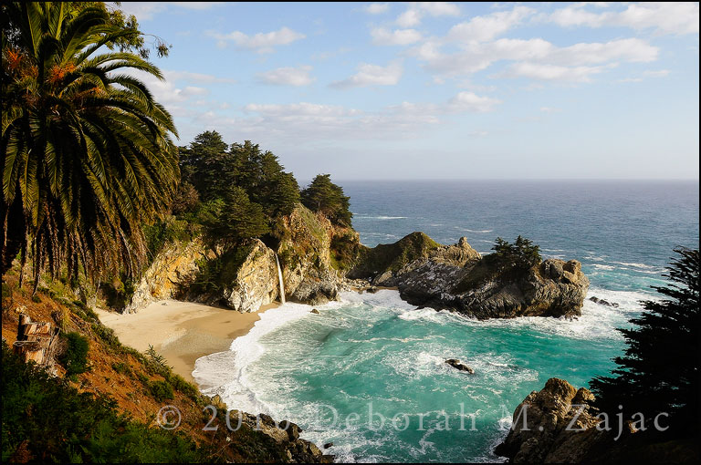
Splash!


Splash!, originally uploaded by dmzajac2004.

Copyright © 2010 Deborah M. Zajac. All Rights Reserved.

Fort Point
Guard
San Francisco
California
Golden Gate Bridge

Another short stop on the way to Fort Baker for a Meet-up.

Fort Point has stood guard at the narrows of the Golden Gate for nearly 150 years. It has been called “the pride of the Pacific,” “the Gibraltar of the West Coast,” and “one of the most perfect models of masonry in America.” When construction began during the height of the California Gold Rush, Fort Point was planned as the most formidable deterrence America could offer to a naval attack on California. Although its guns never fired a shot in anger, the “Fort at Fort Point” as it was originally named has witnessed Civil War, obsolescence, earthquake, bridge construction, reuse for World War II, and preservation as a National Historic Site.

Fort Point was built between 1853 and 1861 by the U.S. Army Engineers as part of a defense system of forts planned for the protection of San Francisco Bay.
~National Park Service

“Go forth under the open sky, and listen to Nature’s teachings.”~William Cullen Bryant

Copyright © 2010 Deborah M. Zajac. All Rights Reserved.

Rocky Point
Hwy 1
Cabrillo Highway
Monterey County
California Coast

A friend and I spent the day driving the down the coast scouting out locations for a Meet-up. We came home with a plan.

GRRR! I did it again. Forgot to reset my ISO from the shoot before. Thank goodness this camera can handle higher ISO’s sans horrendous noise.
Love my D300s!

“The Greatest Meeting of Land and Sea”

Big Sur is located along Scenic Highway One approx 150 miles south of San Francisco and 300 miles north of Los Angeles.
Historically, the name Big Sur was derived from the unexplored and unmapped wilderness area which lays along the coast south of Monterey. It was simply called el pais grande del sur, the Big South Country. Today, Big Sur refers to that 90 miles stretch of rugged and awesomely beautiful coastline between Carmel to the north and Simeon (Hearst Castle) to the south. Highway One winds along its length and is flanked on one side by the majestic Santa Lucia Mountains and on the other by the rocky Pacific Coast.
~bigsurcalifornia.org